An official website of the United States government.
 Official websites use .gov
A .gov website belongs to an official government organization in the United States.
Official websites use .gov
A .gov website belongs to an official government organization in the United States.
 Secure .gov websites use HTTPS
A lock or https:// means you’ve safely connected to the .gov website. Share sensitive information only on official, secure websites.
Secure .gov websites use HTTPS
A lock or https:// means you’ve safely connected to the .gov website. Share sensitive information only on official, secure websites.
There is considerable interest in the offshore exploration, and possible development, of hydrocarbon resources in Alaska’s Chukchi and Beaufort shelf seas. Drilling activity can only proceed during the open water season, with the extent of that season dictated by sea ice formation, as determined by federal permitting agencies. Federal agencies and the oil and gas industry require an accurate method of predicting sea ice formation since a premature or delayed cessation of marine operations based on inaccuracies in either model predictions or satellite detection of sea ice formation could be costly and have implications for the safety of offshore operations. The National Weather Service (NWS) and NOAA are tasked to develop sea ice prediction models having an unprecedented ability to forecast accurately the onset of sea-ice formation. This process is difficult because such forecasts require knowing the vertical temperature and salinity structure (the stratification) of the shelf and how this evolves as a function of air-sea heat fluxes.
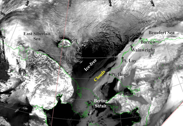
November 24, 2013 AVHRR image illustrating the differences in ice cover on the East Siberian, Chukchi, and Alaskan Beaufort seas.
In 2014, the University of Alaska Fairbanks was awarded a three year grant to develop and test an economical sensor package, using existing sensors in a new manner, for operational use by a variety of stakeholders needing accurate predictions of the onset of fall ice formation. The sensor system serves several purposes. First, it provides real-time data on the vertical temperature and salinity structure of the shelf so that agency permitting agencies, and stakeholders, including the oil and gas industry and subsistence users, will know when offshore sea ice formation begins. Second, the data can be used to evaluate and refine NOAA and NWS sea ice forecast models (both existing models and those under development), which depend upon accurately predicting the seasonal evolution of the thermohaline structure of the ocean. Third, the data obtained from this sensor system could be useful in guiding remote sensing algorithms for frazil ice detection, a notoriously difficult process for remote sensing platforms.
The sensor package includes temperature/conductivity/pressure CTD recorders that record internally and transmit data (via a conducting wire) to a small surface buoy. The mooring will also have an acoustic release connected to an anchor and sub-surface flotation (positioned midway along the mooring wire). The surface buoy package will include a thermistor, a GPS sensor, and an Iridium communications system for transmitting the data to shore in real-time. The CTDs (deployed at nominal depths of 8, 20, 30 and 40 m) allow knowing when the entire water column is at the freezing point at which time further cooling will induce frazil ice formation.
Project Details
Funded activities are listed below by implementation year. Status updates will be added to this page as the project progresses.
Year 1 - $161,905 (September 2014 – August 2015):
-
Test and prepare mooring for deployment. The mooring will be built and deployed in Resurrection Bay near-shore and accessible by small vessel from the University of Alaska’s Seward Marine Center. Here the communications, CTD operation, and burn wire mechanism will be tested. Assuming satisfactory results, the mooring will be recovered and prepared for a year-long deployment (summer 2015- summer 2016) in the northeastern Chukchi Sea. Update: The buoy was deployed on September 6, 2015 approximately 76 miles NNW of Wainwright in the Chukchi Sea from the Norseman II vessel. This site was chosen as it is within 2 km of the Chukchi Environmental Mooring (CEM) and thus the freeze-up buoy and its real-time data adds to that large observational effort. Real-time data showed a rapidly cooling upper ocean from September 6th to October 12th. At this time the upper ocean was at the freezing point. However, the buoyshowed that heat remained at depth, preventing ice to form. This heat was advected north by oceanic currents or intrapycnal eddies. This means that entities such as the Canadian Ice Service and the US National Ice Service, based on satellite information alone, might have determined freeze up to 2-3 weeks too early.
-
Develop publically accessible website. In conjunction with the Alaska Ocean Observing System (AOOS), UAF will establish a publicly accessible webpage so that the CTD data are updated in near real-time through summer and fall of 2015 (until the surface float is released). The webpage will be updated daily (at least) and we will present the time series plots of the temperature, salinity, and degrees above freezing point. Update: UAF collaborated with AOOS and brought two websites online, one hosted by UAF and one by AOOS, both with real-time data display and project information.
Year 2 - $86,240 (September 2015 – August 2016):
-
Continue providing real-time data through publicly accessible website until the surface float is released. Update: UAF collaborated with AOOS and brought two websites online, one hosted by UAF and one by AOOS, both with real-time data display and project information.
-
Recover the mooring. After recovering the mooring in summer 2016, UAF will examine the mooring components to assess wear, post-calibrate the CTDs. Update: A recovery attempt for the buoy was made in the Fall 2016 by the U.S. Coast Guard Cutter Healy, but was unsuccessful. Pacific Gyre has delivered a second buoy on time, and UAF is in coordination with the NWS about possible new deployment locations for the new buoy, which will be deployed in the summer of 2017.
Year 3 (September 2016 – August 2017)
-
UAF will continue to examine the mooring components to assess wear, post-calibrate the CTDs and prepare a final technical report by the end of May 2017. Assuming success, UAF will present the project’s results at the Alaska Marine Science Symposium in January 2017 and prepare a paper for publication in the Marine Technology Society Journal. The paper will detail the design, fabrication, lessons learned, and results of the research. The intent is that a multitude of users could then build a similar system for similar applications.
For more information about IOOS’ Ocean Technology Transition Program, please contact Tiffany Vance, Project Manager.
Project Partners