 An official website of the United States government.
 Official websites use .gov
A .gov website belongs to an official government organization in the United States.
Official websites use .gov
A .gov website belongs to an official government organization in the United States.
 Secure .gov websites use HTTPS
A lock or https:// means you’ve safely connected to the .gov website. Share sensitive information only on official, secure websites.
Secure .gov websites use HTTPS
A lock or https:// means you’ve safely connected to the .gov website. Share sensitive information only on official, secure websites.
Partnerships, alliances, and collaborators are how U.S. IOOS® bridges the gap from the local to the global, and how we create products and services to address domestic needs and interests all across the country. IOOS is comprised of 17 federal agencies and 11 regional associations (RAs). Additional partners include a large and growing number of organizations including industry, academia, state, local, and tribal governments, and other federal and non-federal organizations.
Industry Partners
High Frequency Radar
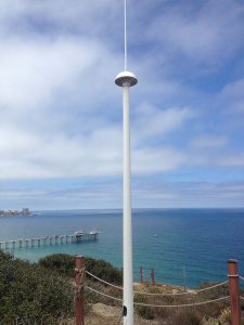
HF Radar installation in California. Photo Credit: IOOS/NOAA
A significant part of IOOS' mission is to establish and maintain a HF-Radar network delivering data about U.S. waters to users nationwide. These data include hourly surface current files delivered to NDBC and files on-demand via THREDDS, as well as wave data. These HF-radar measurements support critical weather and marine forecasting operations at NOAA's Office of Coast Survey, CO-OPS Tides & Currents, and Weather Forecasting Offices throughout the country.
A critical industry partner for HF-Radar is CODAR Ocean Sensors. Working in the field since the 1960's, CODAR Ocean Sensors has produced approximately 80% of all HF radars ever built worldwide, with a total operating time of over 2,000,000 hours. Continual improvement to hardware and software design over that time allows their SeaSonde® line of HF-radars to produce high-quality data output, with robust field performance and user-friendly software making it both convenient and affordable for a wide variety of users and applications.
Profiling Gliders
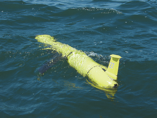
The Scarlet Knight, first underwater robot to make a transatlantic crossing.
Profiling gliders developed by industry have quickly become an indispensable platform for data collection for IOOS. Theses gliders allow safe data collection in locations and weather conditions that could endanger humans and at lower financial cost. In 2009, IOOS Partner MARACOOS successfully flew a glider across the Atlantic from Rutgers University in New Jersey to Baiona, Spain--the very first transatlantic crossing of an underwater robot. In 2010 during the Deepwater Horizon disaster, five US IOOS partners provided gliders to monitor hydrocarbons in the water column.
Teledyne Webb Research, located in Falmouth, Massachusetts, manufacturers the Slocum glider, which is used by several IOOS Regional Associations.
Wave Gliders
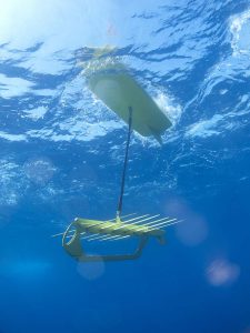
Liquid Robotics Subsea Wave Glider at work.
Wave gliders are a developing technology of real value to U.S. IOOS. These gliders continuously harvest energy from waves and the sun allowing them to travel long distances, hold station, and monitor vast areas without the need for refueling or ship support. In 2015, GCOOS, NOAA, and Liquid Robotics deployed a trio of wave gliders into the Gulf of America (formerly Gulf of Mexico) to be directed into hurricanes over a 90-day mission. Their aim was to gauge the gliders' robustness and reliability in harsh weather conditions, ultimately to collect data to improve hurricane forecasts.
Liquid Robotics, who build and manufacture the wave glider, began as a joint venture between Jupiter Research Foundation and Roger Hine to develop an unmoored, station-keeping data buoy for monitoring humpback whales-the original impetus for the wave glider we know today. The Wave Glider is a configurable platform designed to support a wide variety of sensor payloads. It can keep station or travel from point to point. Data is transmitted to shore via satellite, and the continuous surface presence means that data can be delivered as it is collected. Payloads can be installed by customers or integrated by Liquid Robotics.
Value-Added Companies
Surfline is the leading provider of surf report, forecast and editorial content to consumers, businesses and government agencies worldwide. Founded in 1985 to help surfers find waves, the company's offerings have expanded to include FishTrack (leading fishermen to fish) and BuoyWeather (providing timely marine weather data by GPS point). What makes Buoyweather unique is its network of "Virtual Buoys" that provide focused marine data for every coastal and offshore area in the world. From each virtual buoy point, users are able to gauge current wind speeds and swell heights, as well as garner a seven-day marine forecast for that precise location.
WeatherFlow, Inc. is a leader in accurately monitoring, modeling, and forecasting wind and weather conditions for specific applications. Using one or more custom-designed observing networks, its professionals integrate additional weather and oceanographic data from official sources, including U.S. IOOS, incorporate that data in a high resolution weather model, and apply decades of forecasting experience. The result is a high quality suite of weather products and services that is unmatched in the industry today.
Roffer's Ocean Fishing Forecasting Service, Inc. (ROFFS™) is a scientific consulting company based in Miami and West Melbourne, Florida, that is involved with fisheries oceanography, environmental science, and satellite remote sensing. It is best known for its tactical and strategic fisheries forecasts that are the result of the integration of satellite and other fisheries oceanographic data. ROFFS is intensively involved in a broad range of projects such as ship routing, oil and gas drilling operations, seismic and fish surveys, fisheries development, aquaculture, environmental monitoring, and applied scientific research.
Programs
The National System of Marine Protected Areas (MPAs)
IOOS data are important for the design, monitoring and assessment of MPAs and MPAs can serve as reference sites for operation of monitoring equipment. Coordination between NOAA, the Department of the Interior, other Federal and State agencies, non-governmental organizations and universities offers the National System of MPAs and IOOS mutual benefit from increased data standards and improved dissemination of information to the public and decision makers. Our Nation will benefit from enhanced ecosystem-based approach to manage marine resources and improve marine ecosystems.
Linking IOOS to MPAs
The National Water Quality Monitoring Network for U.S. Coastal Waters and Tributaries
NOAA is working with the Environmental Protection Agency, U.S. Geological Survey, and other national and regional partners to develop integrated approaches to manage, protect, and monitor our nation’s water resources. The Network integrates biological, chemical, and physical features and links uplands tributaries to the coastal ocean. It represents an integrated, multidisciplinary, and multi-organizational approach that leverages diverse sources of data and information; augments existing monitoring programs; and links observational capabilities. These networks include IOOS, the IOOS Regional Associations, and other federal agencies and represent a broad community of users – including coastal and inland states, tribes, researchers, and non-governmental organizations.
Linking IOOS to NWQM
United States Group on Earth Observations (USGEO)
In 2005, USGEO was established under the White House Office of Science and Technology Policy’s Committee on Environment and Natural Resources to lead federal efforts to achieve a national Integrated Earth Observation System (IEOS). Through USGEO, the U.S. further supports cooperative, international efforts to build the Global Earth Observation System of Systems (GEOSS). GEOSS is being developed through the intergovernmental Group on Earth Observations (GEO), a partnership of 80 countries, the European Commission, and nearly 60 international organizations.
USGEO includes representatives from 17 federal agencies and the Executive Office of the President. USGEO is co-chaired by representatives of the White House Office of Science and Technology Policy (OSTP), the National Oceanic and Atmospheric Administration (NOAA), and the National Aeronautics and Space Administration (NASA).
Documents
|
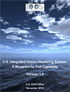
U.S. Integrated Ocean Observing System: A Blueprint for Full Capability (pdf) defines the specific activities and systems that will make up the fully operational U.S. IOOS and guides the efforts of partners and the U.S. IOOS Program. |
|
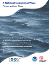
The U.S. Army Corps of Engineers (USACE) and the National Oceanic and Atmospheric Administration's (NOAA) National Data Buoy Center (NDBC) have long led the nation with wave observation programs, but the observation locations were based on local project or user requirements, resulting in a useful but ad hoc network with limited integration. A National Operational Wave Observation Plan (pdf) addresses this situation by defining a comprehensive wave observing network for the United States. The initial version of the plan was completed in 2009. |
|
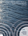
U.S. IOOS® National Surface Current Mapping Plan (pdf) presents the uses of high frequency radar, the requirements that drive the measurement of ocean surface currents, and the implementation design for a five-year, national build out effort. |
Federal Agencies
 |
National Oceanic and Atmospheric Administration (NOAA) |
 |
National Science Foundation (NSF) |
|
National Aeronautics and Space Administration (NASA) |
Environmental Protection Agency (EPA) |
||
|
Bureau of Ocean Energy Management, Regulation and Enforcement (BOEM and BSEE) |
 |
Marine Mammal Commission (MMC) |
|
|
Office of Naval Research (ONR) |
 |
Oceanographer of the Navy, representing the Joint Chiefs of Staff (JCS) |
|
 |
U.S. Army Corps of Engineers (USACE) |
 |
U.S. Coast Guard (USCG) |
 |
U.S. Geological Survey (USGS) |
Department of Agriculture, Cooperative State Research, Education, and Extension Service (CSREES) |
|
 |
Department of Energy (DOE) |
 |
Department of State (DOS) |
 |
Department of Transportation (DOT) |
 |
Food and Drug Administration (FDA) |
 |
U.S. Arctic Research Commission (USARC) |