 An official website of the United States government.
 Official websites use .gov
A .gov website belongs to an official government organization in the United States.
Official websites use .gov
A .gov website belongs to an official government organization in the United States.
 Secure .gov websites use HTTPS
A lock or https:// means you’ve safely connected to the .gov website. Share sensitive information only on official, secure websites.
Secure .gov websites use HTTPS
A lock or https:// means you’ve safely connected to the .gov website. Share sensitive information only on official, secure websites.
How does IOOS affect you?
Integrated data is critical to timely action, decisions, and response for everyone from world leaders responding to crisis to a surfer headed out to catch some waves. U.S. IOOS delivers the data and information needed to increase understanding of our coastal waters, so that everyone can take action to improve safety, enhance the economy, and protect the environment. Scientists working to understand climate change, governments adapting to changes in the Arctic, communities monitoring local water quality, industries understanding coastal and marine spatial planning all have the same need: reliable and timely access to data and information that inform decision making.
Photo Credit: U.S. Coast Guard/PAC Tom Sperduto There's no swapping of business cards in a crisis. Whether it's tracking current information to narrow a search zone for a mid-ocean rescue, utilizing predictive models of storm surge along with real-time and historical observing data to plan response and recovery, or tracking and predicting harmful algal blooms to avoid toxins entering the community water and food supply, IOOS has an established network of local and regional observing systems offering quality-tested, compatible, and freely-accessible data to fit any need.Safety

"Chá bă," a new buoy off the coast of Washington, contributes better information about the ocean conditions that oysters can and cannot tolerate. Maritime economy contributed $282 billion ad 2.8 million jobs to the U.S. economy in 2011. From the clothes you wear to the food on your table and the electronics you do your job on, the business of the ocean and Great Lakes touches everyone in the country, and IOOS provides data and information services that maximize the operational abilities and productivity for anyone and everyone who works with or along our coasts. From collaborating on NextGen Nav systems to prevent groundings in busy ports, to showing commercial fishermen ocean conditions for the day ahead, to innovating new ways to identify and forecast ocean acidification events to stabilize shellfish hatcheries, IOOS data is at the heart of it all.Economy

(Photo credit: Dr. John Payne, Pacific Ocean Shelf Tracking Project)
Environment
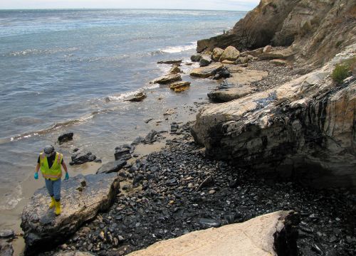
Oil-covered rocks at Refugio State Beach (photo credit: NOAA)
From industry to weather, the ocean and Great Lakes are literally a driving force in our daily lives, and changes to that ecosystem can have far-reaching effects. Integrated, big-picture data helps scientists monitor climate change, communities and governments track oil spill paths and boost coastal resilience, and government and industry assess ecosystem conditions for offshore energy development assuring that it's attainable and sustainable.