 An official website of the United States government.
 Official websites use .gov
 Secure .gov websites use HTTPS
State-of-the-Art Nutrient Sensing Technology to Develop an Operational Nutrient Observatory for the Northeastern United States
Coastal and offshore shelf waters of the Northeast United States are seeing fluctuations in the levels of dissolved inorganic nutrients, driven principally by human caused nutrient loading near shore and oceanographic processes farther offshore. Anthropogenic inputs near-shore lead to eutrophication and associated hypoxia, habitat loss, and degraded aesthetic value. Changes in nutrients offshore appear to be occurring due to climate change, and are a key factor influencing development of Alexandrium harmful algal blooms, which cause Paralytic Shellfish poisoning. Supportive data with which to wisely assess and manage these nutrient fluxes in New England waters remain lacking. These data can only be delivered by an effective coastal nutrient observatory. Recent advances in nutrient sensor technologies, coupled with considerable leverage from ongoing coastal ocean observing programs, now make this possible for the first time, anywhere in the world.
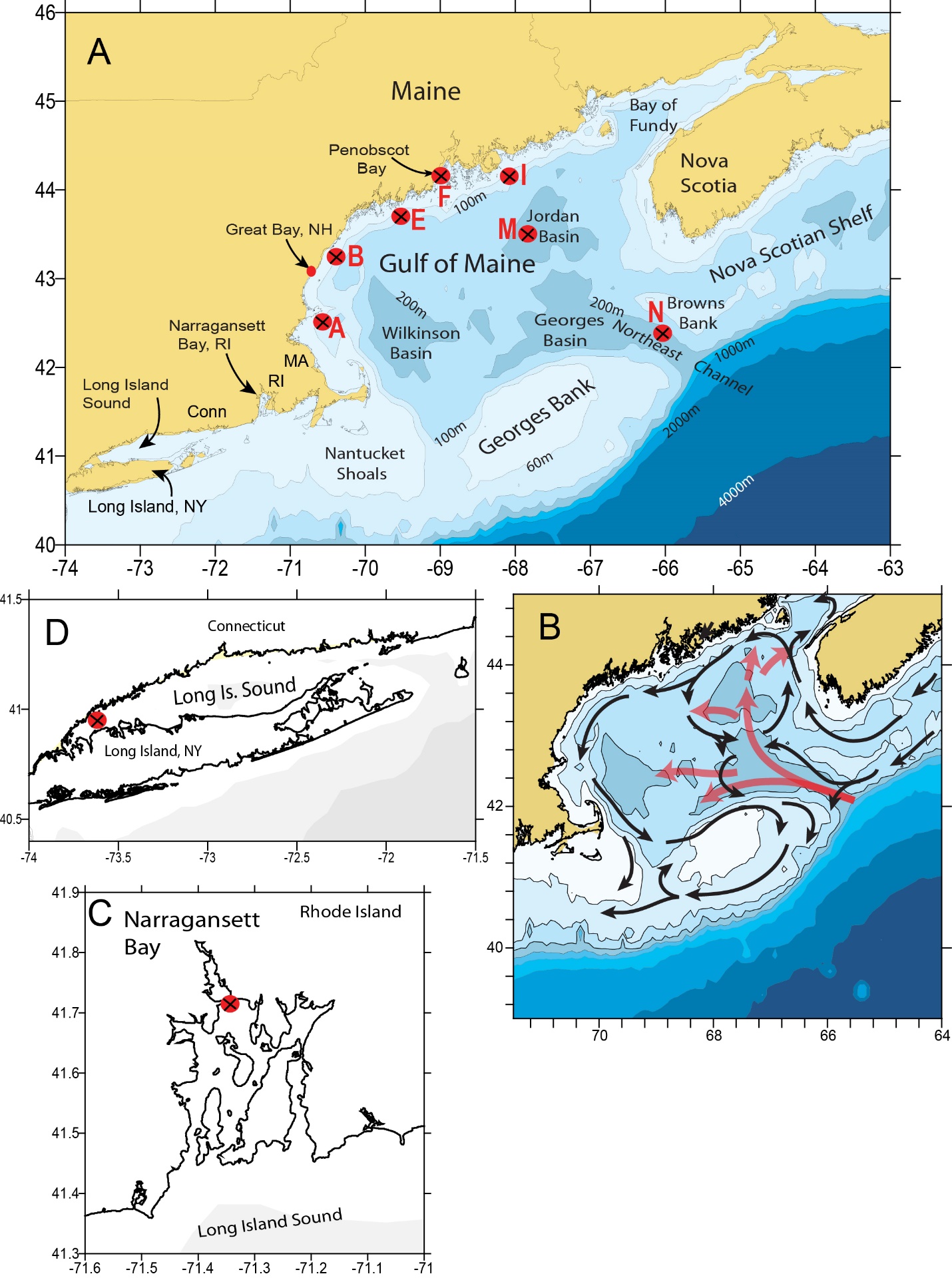
Nutrient monitoring sites throughout the Northeast. Click graphic for larger view.
In 2014, IOOS’ Ocean Technology Transition Project awarded a three year grant to the Northeast Atlantic Coastal and Ocean Observing System (NERACOOS) to develop an integrated nutrient observatory capable of resolving nutrient dynamics at temporal and spatial scales necessary to address critical needs of stakeholders throughout the Northeast region of the United States.
As part of the this project, fifteen (15) new and two (2) refurbished Satlantic SUNA (Submersible Ultraviolet Nitrate [NO3] Analyzer) v2 sensors will be integrated on current NERACOOS mooring assets in western Long Island Sound, upper Narragansett Bay, Great Bay in New Hampshire, Massachusetts Bay, 3 sites along the coastal shelf of the Gulf of Maine, at four depths in Jordan Basin in the interior Gulf, and at one depth in the Northeast Channel, between Georges and Browns Bank. In addition, three (3) new and one refurbished WET Labs Cycle-PO4 and four (4) WET Labs Cycle-NH4 sensors will be deployed at the near-shore sites listed above. Each of these sites has specific environmental concerns with strongly invested stakeholders. The goal is to develop continuous, year round nutrient monitoring in the Northeast. In 2015, NERACOOS launched a website for the Northeast Nutrient Observatory where you can access information about the project. The website is located here.
Project Details
Funded activities are listed below by implementation year. Status updates will be added to this page as the project progresses.
Year 1 - $600,000 (September 2014 – August 2015):
- NERACOOS hosted a stakeholder workshop in May 2015. During the workshop project stakeholders and partners reviewed detailed deployment requirements for the nutrient sensors at the different sites. NERACOOS also worked with end-user stakeholders to define operational information requirements, delivery tools, and visualizations.
- The first phase of sensor deployments will involve the acquisition, integration, and deployment of 5 SUNA (purchased), and 1 Cycle-NH4 sensors (purchased), and 1 Cycle-PO4 (leveraged). These instruments will be calibrated in the laboratory, followed by mechanical, data, and power integration with the specific mooring platforms. The SUNAs will be deployed in the spring-summer of 2015 as follows: 2 m depth on the Great Bay, NH mooring maintained by UNH; 50 m depth on Buoy I on the Maine coastal shelf; 50, 100, and 250 m depths on the offshore Jordan Basin mooring in the interior Gulf of Maine (Buoy M); and 180 m depth in the Northeast Channel boundary of the Gulf of Maine (Buoy N). The Gulf of Maine buoys are maintained by U. Maine. The Cycle-PO4 and Cycle-NH4 sensors will be installed on the Great Bay mooring.
Update: The Great Bay buoy was deployed on in 2015 and 2016 and housed Cycle Phosphate and SUNA Nitrate sensors including a Beta Cycle Phosphate for testing. Discrete water samples were also taken and analyzed. The buoy was re-deployed in April 2017 and will carry a cycle phosphate sensor and a cycle ammonium sensor.
-
Data from the SUNA Nitrate and Cycle Phosphate sensors in the Great Bay are available online through the NERACOOS Real Time Data Portal.
-
In addition to laboratory calibrations of the sensors prior to deployment, ground-truth water samples for laboratory nutrient analyses were collected at times of deployment and servicing and through existing sampling programs in the various sub-regions for ongoing verification.
Year 2 - $700,000 (September 2015 – August 2016):
- 7 more SUNA, 2 more Cycle-PO4, and 2 more Cycle-NH4 sensors will be acquired, integrated, and deployed. Eight of the SUNAs will be used for annual turn-arounds for the Gulf of Maine deployments (Buoys I, M, and N), which are expected to occur in summer 2016. Each of these sites has a duplicate mooring that is deployed when the in-water mooring is retrieved. Update: The SUNA Nitrate sensors have been deployed at Buoy E, I and N at depths of 50m, 100m, and 180m. Buoy M was deployed by the University of Maine in October with six SUNA Nitrate Sensors mounted at 1m, 20m, 50m, 100m, and 250m depths. Buoy M broke free of its mooring in February 2017 during a storm. The buoy and its associated sensors were recovered and will be redeployed in spring 2017.
- Additional SUNA and Cycle sensors (1 of each) will be used to enable quick servicing of the inshore moorings, so there will always be a newly serviced sensor ready for deployment.
- SUNA deployed at 2 m depth, Cycle-PO4, and Cycle-NH4 deployed on the western Long Island Sound (LIS) buoy maintained by U. Conn. Update: Sensors were deployed and integrated into the new Western Long Island Sound buoy in December 2016. The sensor package includes a cycle phosphate sensor and cycle ammonium sensor.
- Data from these sensors is available online through the NERACOOS Data Management System.
- NERACOOS will meet with stakeholders to review data needs and obtain feedback on the real-time data that is visualized and available for download from the NERACOOS website. The workshop is scheduled for February 2016. Update: Based on feedback from the initial nutrient stakeholder workshop, the PIs postponed the Long Island Sound workshop until the nutrient sensor deployment occurred. The Western Long Island Sound buoy was deployed in 2017 and the team is now in the process of planning this workshop. This workshop will be held in May or June of 2017.
- NERACOOS will work with the WHOI red tide modeling team to incorporate interpreted nutrient fields into predictive HAB models (He et al., 2008), which currently rely on historical climatology (Rebuck et al., 2009; Rebuck and Townsend, 2013).
- We will establish and refine sensor QA/QC documentation and protocols following guidance as provided through the IOOS Quality Assurance of Real Time Ocean Data (QARTOD). Update: Work continues between partners to develop QA/QC procedures.
Year 3 (September 2016 – August 2017):
- One more SUNA will be deployed for the first time on buoy A (Mass. Bay)). A SUNA, Cycle-PO4, and Cycle-NH4 will also be deployed on the Conimicut Point, Narragansett Bay mooring maintained by URI and owned by RI DEM. Update: The Narragansett Bay Commission has been selected as our partners for the Narragansett Bay deployment, and they will deploy the SUNA Nitrate in spring 2017.
- The final two sets of Cycle-PO4 and Cycle-NH4 sensors will be deployed on buoys A (Mass. Bay) and F (Penobscot Bay) in the fall of 2016.
- Data from these sensors will be made available online through the NERACOOS Data Management System. Update: Data from the SUNA Nitrate and Cycle Phosphate
sensors in Great Bay continued to transmit through the NERACOOS Data Management System via the Real Time Data Portal. GMRI and UNH continue to work towards making the historical data available through other NERACOOS tools. GMRI is now serving UMaine nutrient data though the NERACOOS ERDDAP system (http://www.neracoos.org/erddap/index.html). GMRI and UConn are working on integrating the UConn data into the NERACOOS data system. - Training of local technical staff will transition to fully operational maintenance.
- NERACOOS will continue to work with our stakeholders in Year 3 working to refine data products, processing, archiving, and user access within NERACOOS.
- NERACOOS will continue working with the red tide modeling group at WHOI as they continue to refine the A. fundyense Gulf of Maine model and move toward its development into an operational NOAA forecast model. Data will be analyzed and presented to the research and management communities in an effort to expand stakeholder participation for the new nutrient observatory data products.
- NERACOOS will conduct stakeholder meetings to describe the major outcomes of the project including successes, challenges and data access tools. Update: This workshop is planned for May or June of 2017.
- All nutrient sensors deployed for this project will become permanent nodes of a NERACOOS Northeast nutrient observatory.
For more information about IOOS’ Ocean Technology Transition Project, please contact Tiffany Vance, Project Manager.