Deployment of an Operational System for Acquiring and Disseminating Oceanographic and Behavioral Data Telemetered from Tagged Sharks
Animal-borne sensors can be an effective method for collecting oceanographic data and, in certain circumstances, may be able to provide wider, more detailed and more cost-effective coverage than ‘traditional’ oceanographic tools. These environmental data are collected simultaneously with information concerning the habitat use and behavior of the tagged animals.

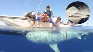
Researchers tagging a tiger shark as part of the second phase of a project to observe the movements of tiger sharks caught and tagged around the island of Maui. Source: Hawaii Institute of Marine Biology.
Recent advances in animal telemetry include successful testing and calibration of tag-borne sensors (oxygen, temperature, depth, ambient light), development and refinement of data compression and transmission algorithms, and, crucially, the deployment and testing of land-based relay receivers that dramatically improved data throughput as compared with data acquired solely via the Argos satellite system. Incorporation of fast acquisition GPS capability into shark tags now allows greatly improved geolocation accuracy regarding the site of origin of the collected data. Tag attachment techniques have been refined resulting in reliable long-term term deployments that frequently exceed a year.
In 2015, IOOS’ Ocean Technology Transition Project provided funds, through the Pacific Islands Ocean Observing System (PacIOOS), to the Hawaii Institute of Marine Biology (UH) for a two-year project to establish a functional Operational System for Acquiring and Disseminating Oceanographic and Behavioral Data Telemetered from Tagged Sharks covering the main Hawaiian Islands. The project will initially focus on deploying environmental sensor tags on tiger sharks caught within the coverage footprint of the array but exploratory deployments will also be made with six gill and hammerhead sharks. Tiger sharks sample the water column between the surface and approximately 300 meters while six-gill sharks sample between 300 and 1000 meters. Data will be acquired via the Argos satellite system and through land-based relay receivers installed on several islands as part of this project. All relevant data will be relayed to the Global Telecommunications System (GTS) and similar data bases. Previous results indicate that areal coverage will range from very nearshore out to several hundred miles from the Hawaiian Islands. New types of tags will be tested in the array as they become available from our industry partner.
UH will work in close collaboration with its primary industry partner Wildlife Computers, Inc., located in Redmond, WA, to ensure continued technical support of the data relay receivers, the continued refinement of the environmental sampling algorithms - e.g., “virtual cast” software that transcribes animal-acquired environmental data into a format analogous to a CTD (Conductivity, Temperature, and Depth) cast, and continued beta-testing of new sensors such as salinity/conductivity and chlorophyll. An interrelated activity will be continued deployment and evaluation of miniaturized video camera packages.
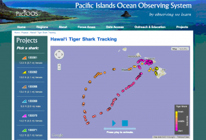
The implementation and administration of the proposed system will be tightly coordinated with the PacIOOS program at the University of Hawaii’s Joint Institute of Marine and Atmospheric Science (JIMAR). PacIOOS will receive data from the integrated observation system and, importantly, will act as the portal for automated uploading of environmental data into the GTS and other large scale data archives. PacIOOS will continue to support the tagging project’s extremely popular Shark Tracking web site which disseminates shark behavioral data to the general public.
Project Details
Planned activities are listed below by implementation year. Status updates will be added to this page as the project progresses.
Year 1 - $371,250 (September 2015 – August 2016):
- Identify appropriate sites and install land-based relay receivers on Hawaii Island, Oahu, Maui (2 -3 sites each island - we already have two on Maui).
- Equip tiger sharks, six gill and hammerhead sharks with environment sensing satellite transmitter tags. Animals will be tagged around Oahu, Maui and Hawaii Island.
- Establish PacIOOS protocols for relay of environmental data to GTS and other archives. Commence automated transfer of data acquired through the array.
- Evaluate results, prepare evaluation reports for IOOS, and disseminate results at symposia.
Year 2 (September 2016 – August 2017):
- Service the land-based receivers and, if necessary, reposition them based on Year 1 performance.
- Increase the number of environment sensing tags deployed to maximize environmental data throughput. Specific species mix will be based on performance of Year I.
- Beta-test new types of sensor tags (salinity, chlorophyll, feeding sensors).
- Report on findings and seek funding for continued operation of the array.
For more information about this project and shark tagging, please contact Dr. Kim Holland.
For more information about IOOS’ Ocean Technology Transition Project, please contact Tiffany Vance, Project Manager.
Click here for more information about Animal Telemetry.
Additional Resources:
Pacific Islands Ocean Observing System (PacIOOS)
Hawaii Institute of Marine Biology (UH)
Project Partners
 Official websites use .gov
A .gov website belongs to an official government organization in the United States.
 Secure .gov websites use HTTPS
A lock or https:// means you’ve safely connected to the .gov website. Share sensitive information only on official, secure websites.


