 An official website of the United States government.
 Official websites use .gov
A .gov website belongs to an official government organization in the United States.
Official websites use .gov
A .gov website belongs to an official government organization in the United States.
 Secure .gov websites use HTTPS
A lock or https:// means you’ve safely connected to the .gov website. Share sensitive information only on official, secure websites.
Secure .gov websites use HTTPS
A lock or https:// means you’ve safely connected to the .gov website. Share sensitive information only on official, secure websites.
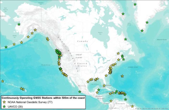
Available GNSS stations within 500m from the coasts; yellow indicates NOAA NGS
stations and green indicates UNAVCO stations
Sea level is the height of the sea surface, and is geodetically defined as the vertical reference planes of the earth. Accurate temporal and spatial water level (WL) observations are a critical capability for monitoring and forecasting long- and short-term coastal changes. Accurate temporal and spatial water level (WL) observations are critical capability for monitoring and forecasting long- and short-term coastal changes. The overarching goal of the proposed project is to adapt Global Navigation Satellite System (GNSS) as a new operational WL measurement facility to improve coastal monitoring capability by developing GNSS Water level Observation System (GWOS). To accomplish this goal, the project objectives are:
- to develop an operational WL monitoring GNSS-Reflectometry (GNSS-R) methodology,
- to characterize the site dependent parameters of GNSS-R for east, west, south coasts of the continental US, and Alaska for optimizing GWOS,
- to build a standalone executable software package for producing WL measurements using GNSS-R data.
Funding:
- Year 1: $375,566
- Year 2: $306,525
- Year 3: $380,479
- Total: $1,062,570
Partners:
Oregon State University