 An official website of the United States government.
 Official websites use .gov
A .gov website belongs to an official government organization in the United States.
Official websites use .gov
A .gov website belongs to an official government organization in the United States.
 Secure .gov websites use HTTPS
A lock or https:// means you’ve safely connected to the .gov website. Share sensitive information only on official, secure websites.
Secure .gov websites use HTTPS
A lock or https:// means you’ve safely connected to the .gov website. Share sensitive information only on official, secure websites.
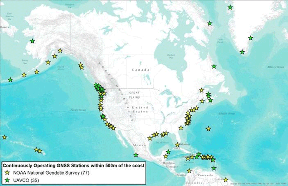
Locations of 112 GNSS stations within 500m of the coasts; yellow indicates NOAA NGS stations and green indicates UNAVCO stations.
Dr. Jihye Park, Oregon State University
Year 1: $375,566
Year 2: $306,525
Year 3: $380,479
Total: $1,062,570
Accurate temporal and spatial water level (WL) observations are a critical capability for monitoring and forecasting long- and short-term coastal changes. The overarching goal of the project is to adapt Global Navigation Satellite System (GNSS) as a new operational WL measurement facility to improve coastal monitoring capability by developing the GNSS Water level Observation System (GWOS). To accomplish this goal, the project objectives are:
- Objective 1: to develop an operational WL monitoring GNSS-Reflectometry (GNSS-R) methodology;
- Objective 2: to characterize the site dependent parameters of GNSS-R for east, west, south and coasts of the continental US, and Alaska for optimizing GWOS;
- Objective 3: to build a standalone executable software package for producing WL measurements using GNSS-R data.
GWOS consists of three components: hardware, software, and site selection. The hardware is any off-the-shelf GNSS facility, which does not require building special hardware. The GWOS software requires innovation since, while the raw data acquisition is relatively easy and convenient, the data processing is complicated. This project focuses on the innovative data processing methodology of GWOS to enable high accuracy and high-resolution water level measurements for near real time applications. The GWOS site selection is crucial due to site dependent factors affecting performance. During the project, the site dependent factors will be investigated at different sites.
GWOS is technically innovative using existing GNSS technology in a new way, cost efficient using any existing GNSS antenna, and has the potential to reach both public and private research communities and the general public. The project will advance the suite of tools that can be used to make coastal WL measurements beyond conventional tide gauges with a new GNSS based technique that will secure more dense WL observations along the U.S. coast with a sustainable measurement tool.
In addition, GWOS is cost-effective because existing GNSS facilities can be used as the hardware component of GWOS. GWOS is a smart investment of resources because the unit will serve not only as a WL measurement tool, but also as a regular GNSS facility, which provides three-dimensional positioning, meteorology, space weather, and geophysical applications. Since GWOS is relatively easy to install and maintain compared with conventional tide gauges, the system can be used in locations of interest where tide gauges are difficult to mount. The versatility of the GWOS system makes it accessible to research and public communities for various WL data applications. The proposed work is committed to be integrated in several IOOS RAs: AOOS, CeNCOOS, and NANOOS. The proposed technology is sufficiently mature for transfer to long term operations, and the code and data will be openly accessible as a part of IOOS.
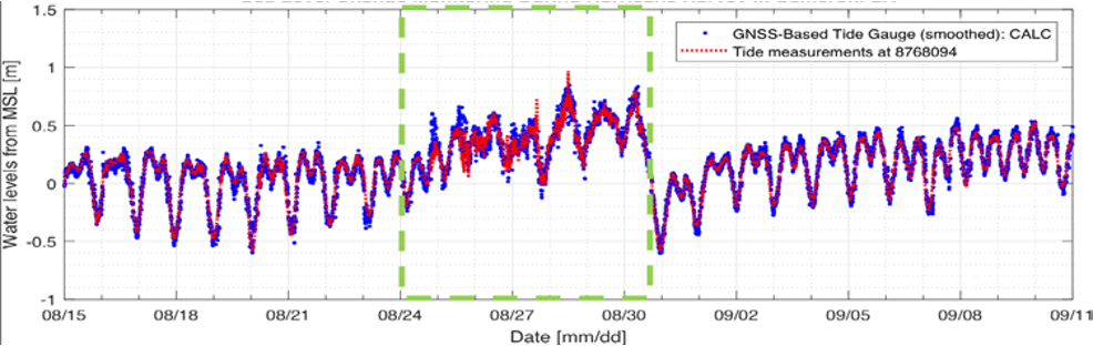
Water Level measurements from NOAA tide gauge (ID: 8768094) and the GNSS station, CALC, shown in blue and red dots, respectively; A storm surge during Harvey is indicated in green dashed box.