 An official website of the United States government.
 Official websites use .gov
 Secure .gov websites use HTTPS
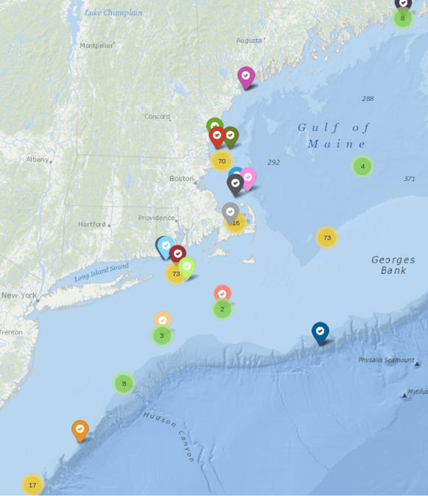
Screenshot of web display from November 22, 2019 showing locations of 370 hauls reporting bottom temperature in the previous month with more than a dozen boats reporting.
Erin Pelletier, Gulf of Maine Lobster Foundation
The team intends to field the first autonomous, multi-parameter, low-cost, benthic data collection system to ever be deployed on the US Continental Shelf. This system will document the rapid changes to our physical environment at an economically feasible cost and will engage generations of fishers who rely on marine resources. The team proposes to significantly upgrade an existing system by:
- adding two new sensors - Dissolved Oxygen and Current (Speed and Direction) - to the existing set of Temperature and Depth;
- integrating cellular and satellite communications modems for near-real-time data reports;
- introducing the system to other IOOS regions beyond the Northeast; and
- improving the reliability of the system so as to reduce field support requirements and cost.
NOAA research vessels survey the continental shelf waters but the infrequent and widely spaced surveys do not detect small scale features or short-term weather-driven events. In addition, the cost to operate the ship ($25-50K per day) is prohibitive. The surveys are valuable, in that they provide a long-term time series of general conditions, but there is a data gap in the information at smaller scales, both temporal and spatial. Some process-oriented studies, by various academic institutions, are conducted in certain areas of the shelf but these efforts are often disparate, not well integrated with the local ocean observing systems and are rarely sustained over multiple years.
But there is an alternate approach. The figure below shows an example of a short term 'event' captured by a lobster boat; we include it here as an example of how IoT fish gear can capture significant events and help fill in the data gap. Fishers are interested in seeing the effect on these relatively fast events on their catch.
Objective: Produce a custom set of instrumentation to measure dissolved oxygen and current.
Activity: Install 40 systems including six in other IOOS regions outside of the Northeast.
Output: Real-time availability of oceanographic information at multiple IOOS regions.
Outcome: Fishers able to make better decisions, research scientists have more data.
Objective: Engage the next generation of fishers and dockside technicians.
Activity: Provide opportunities for the fishing community to be more involved in installing and maintaining the IoT fishing systems.
Output: Region-wide citizen science effort.
Outcome: An ocean literate society and collaboration and cooperation leading to improved regulation compliances by fishers.
Objective: Improve accuracy and reliability of ocean models and forecasts where it is needed most by the maritime industry and coastal recreation users.
Activity: Provide high-quality real-time ocean data in the dynamic shelf zones needed by modelers.
Output: Agile data management structures to ensure timely and reliable data delivery and promote data interoperability between scientific, operational oceanographic, and maritime industry data users.
Outcome: Improved ocean forecasts which now feed into weather models.
Objective: Reduce required field support for system maintenance.
Activity: Implement changes based on lessons learned from prior work.
Output: 50% reduction in setup and maintenance costs.
Outcome: System is more sustainable with a lower cost per data point.
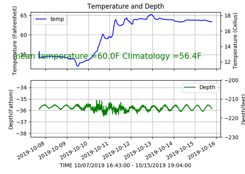
Recent plot as it appeared in a lobsterman’s wheelhouse after a pot with a temperature and depth probe. The plot shows the effect of a Northeaster that passed over his traps in 36 fathoms (66 meters) of water on 11 Oct 2019. Overlaid on the plot is the mean temperature for the time the pot was on the bottom as well as the expected (climatological model) for that time and place.