 An official website of the United States government.
 Official websites use .gov
A .gov website belongs to an official government organization in the United States.
Official websites use .gov
A .gov website belongs to an official government organization in the United States.
 Secure .gov websites use HTTPS
A lock or https:// means you’ve safely connected to the .gov website. Share sensitive information only on official, secure websites.
Secure .gov websites use HTTPS
A lock or https:// means you’ve safely connected to the .gov website. Share sensitive information only on official, secure websites.
The National Operational Wave Observation Plan

In 2009 the Interagency Ocean Observation Committee (IOOC) issued the National Operational Wave Observation Plan, which was developed as an interagency effort coordinated by the IOOS® Program and developed by the US Army Corps of Engineers (USACE) and the NOAA National Data Buoy Center (NDBC). At that time, there were 180 wave observation sites nationwide and just over half reported wave direction at varying directional accuracy. From a national perspective, many were located in an ad hoc fashion and had been located primarily to support weather, not wave observations. The plan proposed a comprehensive system design that established a standard level of accuracy, assessed the existing measurement locations, proposed both new observations in critical gaps locations and upgrades to existing platforms.
Led by the USACE, NDBC and the Naval Meteorology and Oceanography Command, the National Operational Wave Observation Plan was revisited in 2012 to examine the network changes that have occurred and to better recognize the fiscal realities of today. These include:
- Strategic recommendations for directional sensor upgrades;
- A reassessment of the number, location of, and priority for new locations recommended in 2009;
- Tighter integration between wave observations and wave modeling
- Identifying the longest running wave sensors as Sentinel locations critical to wave climate studies.
- Use of short term (~1-2 yr) deployed Rover Buoys specifically to improve local wave model forecasts.
Whereas in the 2009 Waves Plan, every existing wave sensor was automatically included in the design, in the 2012 update, the design is based on the sensors required to create a national perimeter of Backbone Observations for deep ocean, shelf, mid-shelf and coastal wave observations. Backbone locations are of the highest priority for long-term sustainment.
Sensor locations that fall outside the backbone are identified as Supporting Observations. Supporting Observations may be important, even critical locally, but are not as important from a national perspective. Supporting Observations include Rover buoys, gauges that are redundant or too shallow and international locations (i.e. Environment Canada). Supporting Observations are the responsibility of local IOOS regions and partners.
More information can be found in a paper discussing the update, entitled IOOS Wave Observations, a National Perspective (2012) (pdf) which was presented at the IEEE/MTS Oceans’12 conference held in Hampton Roads, VA in October 2012.
An inventory of active wave observation platforms (as of 2012) along with the identification of spatial gaps is available: (1) a KMZ file of the locations which overlays onto Google Earth and (2) an Excel spreadsheet with the details of each station and summary tables. For those without Excel, a printable pdf document created from the Excel spreadsheet is also available.
The KMZ file is particularly powerful for visually exploring various attributes of the wave observing network including coverage, subnet, ownership, service life, directional capabilities, and ranking. Station details including active links to more information and data can be accessed by through each stations icon. Supporting data layers include major port locations, 2009 wave plan locations, tide stations, and more.
Wave observations and Hurricane Sandy, October 2012
During Hurricane Sandy, the Coastal Data Information Program (CDIP) wave buoy network on the East Coast provided continuous, near real-time wave observations (reported every 30 minutes) without failure or interruption. In fact, over 99% of all data produced by CDIP buoys during the storm were successfully transmitted. Read more...
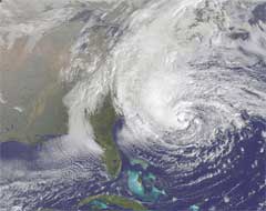 Hurricane Sandy on October 28, 2012. Credit: NASA GOES Project |
 Locations CDIP buoys on the East Coast of the US |